


IT-398

SityTrail - itinéraires balisés pédestres
Tous les sentiers balisés d’Europe GUIDE+

Length
14.5 km

Max alt
1511 m

Uphill gradient
1333 m
Km-Effort
31 km

Min alt
522 m

Downhill gradient
842 m
Boucle
No

Signpost
Creation date :
2022-02-15 00:41:49.924
Updated on :
2022-02-28 19:41:53.274
6h57
Difficulty : Medium

FREE GPS app for hiking
 SityTrail
IGN / Geographical institutes
SityTrail Plus
The world is yours!
About
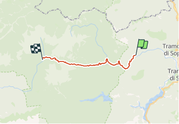
Trail On foot of 14.5 km to be discovered at Friuli Venezia Giulia, Unknown, Tramonti di Sopra. This trail is proposed by SityTrail - itinéraires balisés pédestres.
Description
Trail created by Club Alpino Italiano.
Photos

Positioning
Country:
Italy
Region :
Friuli Venezia Giulia
Department/Province :
Unknown
Municipality :
Tramonti di Sopra
Location:
Unknown
Start:(Dec)
Start:(UTM)
325558 ; 5130291 (33T) N.
Comments